
Flamingo Cay 22.87884°N 075.86923°O
Rocky Point 23.58280°N 076.06638°O
Lire en français
After spending another four days in Georgetown while waiting for a good weather window to cross to the Jumentos Cays and Ragged Island, we hit the road in the morning of March 18 with Croix du Sud and Quasida. Our first stop would be Thompson Bay, Long Island. This overnight stop would allow us to catch the high tide the following morning just in time for the crossing of the Comer Channel. We would then complete the remainder of our 42 NM journey under power to our first Jumentos anchorage: Water Cay.
The Jumentos Cays and Ragged Island are a long stretch of rocks and islands spread out in a semi-circle at the eastern edge of the Great Bahamas Bank. On one side lies the bank with an average depth of twenty feet, on the other is a wall that drops over 2 500 feet to the bottom of the Atlantic Ocean. Such a location requires that one pay particular attention to the weather as there is very limited room to anchor and the constant surge finds a way to wrap around the small islands and make for not so confortable anchorages.
 |
| Leaving Thompson Bay, Michel is looking for starfishes on the bottom |
 |
| Comer Channel |
Leaving Thompson Bay, we had noticed a few sailboats headed for the Comer Channel. We found them again later that afternoon in the small and protected cove at the northern end of Water Cay. An anchorage with a dozen boats wouldn’t be considered crowded anywhere else in the Bahamas; but here, with strong winds stirred up by surrounding squalls and limited protection from the northeast, there wasn’t enough room for everyone.
That left us spending our first night completely exposed to the wind and waves that grew stronger as thunderstorm passed by overnight. However, it wasn’t the wind or the waves that kept us awake, it was something else completely unexpected: the DEA (Drug Enforcement Agency). Late in the evening, long after the sun had set, a non-identified, unlighted helicopter flew overhead at a very low altitude. We could hear it but we couldn’t see it, yet it was right there above our mast. It clearly wasn’t a bunch of tourists taking a ride after dark and no one in the Bahamian law enforcement would go to such extent to catch a few poachers. Somehow, the local fishermen anchored near Croix du Sud appeared convinced that that military type helicopter hovering overhead was after them for a few lobsters and turned off all their lights as it got closer. Ever heard of night vision and infrared sensors guys?
As we couldn’t really figure out who or what was out there and considering that the US Government thought it was worth bringing in a surveillance team, we figured we might as well just call it a night and lock down the hatches and companionway. A few minutes later, the beam of a powerful search light started bouncing off the boats in the anchorage. At that point we started to wish we were somewhere else. Not only had we found Georgetown’s closest suburb, it now appeared to be a pretty sketchy one to say the least. The next morning, catching a conversation on the VHF, we learned that the searchlight was from one of our neighbour who was trying to locate his runaway dinghy. It didn’t bring back the sleep we had lost, but it did help us put some perspective over the previous night.
 |
| Water Cay |
 |
| Water Cay |
 |
| Water Cay |
 |
| Water Cay |
 |
| Sunset in Water Cay |
As for setting the anchor, we never found enough sand to be perfectly satisfied with our holding and, after hitting a submerged rock with the rudder, we gave up on the nice and cozy anchorage close to the beach and moved out near a large commercial fishing boat. We were quite happy with our new and remote location as we could see Croix du Sud and Quasida, first in the small cove, now besieged by their neighbours.
The next day was when all three crews came up to a disappointing conclusion: we were not blown away by the Jumentos as we had hoped to be. There were way too many boats competing for room in the anchorages and, while nice, the fishing was nothing exceptional compared to other places we had been to. Watching the fleet of commercial fishermen going after lobsters in every single coral head around, it wasn’t really surprising that the area seemed to be a little low on the delicious critters. Considering that we saw locals going down with compressed air, it’s clear that the lobsters didn’t stand a chance.
The Chris Parker 0630h weather report (4045kHz on the SSB) from that morning met disappointed sailors that were not very hard to convince that this was definitely not a good place to ride out a cold front. Without any Internet to confirm or contradict the previsions, we had to take the weatherman to his word when he dared use the words “tropical storm” in the middle of March. Common sense and a quick look at the charts made it clear that there would not be enough room to safely shelter everyone that was currently headed south. We went fishing one last time and the next morning picked up anchor and headed towards Rocky Point, Exumas.
 |
| Flamingo Cay caves |
 |
| Lizard |
 |
| Flamingo Cay |
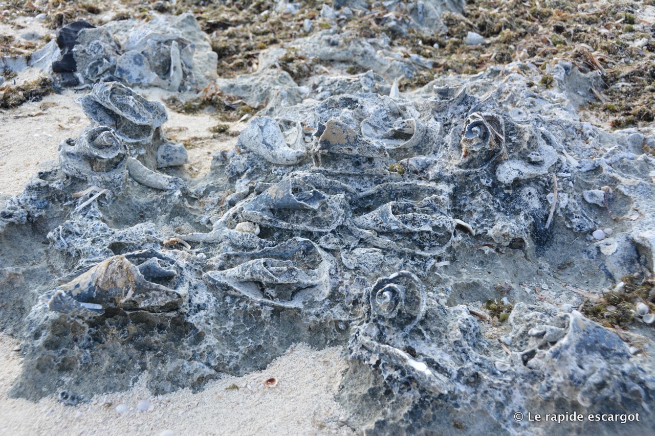 |
| It's great to be able to understand how the islands were created. Conch shells are slowly turning into stone on one of the beaches in Flamingo Cay. |
 |
| Hard to feel isolated and remote when coming across this on the beach. Fishermen or cruisers party? |
 |
| Fishermen at work just before sunset |
 |
| A dolphin near Barraterre! Looks like it could be our youngster and his mom that we met back in January. |
Jumentos Cays
Après avoir attendu notre fenêtre météo à Georgetown pendant quatre longues journées, nous avons finalement pris la route pour les Jumentos Cays et Ragged Islands le 18 mars en compagnie de Croix du Sud et de Quasida. Un arrêt pour la nuit à Thompson Bay, Long Island, nous aura permis d’attraper la marée haute du lendemain pour la traversée du Comer Channel et des 42 NM qui nous mèneraient à notre premier mouillage : Water Cay.
Les Jumentos Cays et Ragged Islands sont une série de petits ilots positionnés en arc de cercle à l’extrémité est du Great Bahamas Bank. D’un côté, le banc avec une profondeur moyenne d’une vingtaine de pieds, de l’autre un mur qui descend à plus de deux milles pieds dans l’Atlantique. Une position géographique pareille oblige donc à porter une attention toute particulière à la météo car les mouillages sont rares et la houle n’est que très peu affectée par ces petits cailloux à la végétation éparse.
Puisque nous attendions des vents légers pour nous rendre dans l’archipel, c’est à moteur que nous avons navigué tout au long de notre séjour qui devait nous mener jusqu’à Duncan Town, aux portes de Cuba. Mais, comme dans tout projet, il y a toujours quelques changements en cours de route. Les guides nautiques nous promettaient un terrain de jeu sauvage, reculé, presque vierge. Nous avons plutôt découvert la banlieue sud de Georgetown…
Au départ de Thompson Bay, nous avions déjà remarqué plusieurs voiliers qui faisaient route vers le Comer Channel qui traverse le banc et ses hauts-fonds. Nous les avons tous retrouvés à Water Cay, dans la petite anse protégée au nord de l’ile. Un mouillage avec une dizaine de bateaux ne serait certainement pas considéré comme surpeuplé ailleurs dans les Bahamas, mais ici, avec l’absence de protection et les vents qui se lèvent avec les orages nocturnes… il n’y avait pas assez de place pour tout le monde. Nous avons donc passé notre première nuit complètement exposés aux vents du nord-est alimentés par les cellules orageuses de passage.
Ce n’est toutefois pas la vague ou le vent qui nous ont empêchés de dormir, nous avons connu pire dernièrement, c’est quelque chose que nous n’aurions jamais envisagé : la DEA (Drug Enforcement Agency). En soirée, nous avons été survolés à quelques reprises par un hélicoptère non identifié, sans feu de navigation et sans aucune lumière. Ce n’était clairement pas un hélico de tourisme et certainement pas la police bahamienne à la recherche de braconniers, même si les voisins de Croix du Sud – des pêcheurs locaux – ont cru bon éteindre toutes leurs lumières à son passage.
À défaut de savoir qui ou quoi se baladait dans les parages où nous comptions passer la nuit, nous avons verrouillé les panneaux de descente et les écoutilles. Lorsque que le faisceau puissant d’une lampe de recherche a commencé à balayer le mouillage, nous aurions préféré être ailleurs. Où étions-nous donc tombés? Non seulement avions-nous trouvé la banlieue de Georgetown, elle nous apparaissait maintenant peuplée d’individus louches. Ce n’est que le lendemain matin que nous avons appris que le dérangeant faisceau était celui d’un équipage en chasse de son dinghy parti à la dérive…
Le lendemain, en route vers Flamingo Cay une des soudures retenant le poteau du radar a lâché comme nous traversions le seul récif du coin. Heureusement que Michel regardait par là; il a réussi à attraper le poteau avant qu’il ne parte à la renverse. Un bout de corde rapidement attaché et le radar était sauvé. Ouf! Dans les mêmes 10 NM nous avons aussi réussi à déchirer la chaussette du spi. Franchement, notre voyage au paradis commençait mal. Cela est sans compter les cinq fois (finalement sept sur deux jours) où nous avons du jeter l’ancre à Flamingo Cay, à la recherche d’un peu de sable où elle pourrait s’enfoncer à notre satisfaction. Heureusement que Caroline et Michel de Quasida ont sauvé la journée en nous offrant du poisson qu’ils venaient tout juste pêcher. Difficile de faire plus frais! Trois requins en ont d’ailleurs profité pour passer se faire un apéro avec les restants pendant que je levais les filets sur la jupe arrière du bateau.
Pour ce qui est de l’ancre, nous n’avons jamais trouvé assez de sable et après que le safran ait cogné contre une roche au fond de l’eau, nous avons fini par aller nous installer à côté d’un gros bateau de pêche un peu plus au large; loin de tous les bateaux empilés dans les deux petites baies. Arrivés en premier, Croix du Sud et Quasida avaient maintenant l’air d’être assiégés par tous leurs voisins.
Le lendemain fut la journée des grandes décisions, les trois équipages étant un peu déçu de ce que nous avions trouvé jusqu’à présent. C’est à dire peu d’espace, beaucoup de monde et, finalement, pas plus de poissons ou de langoustes qu’ailleurs. À voir la dizaine de petites chaloupes quitter le bateau-mère et nettoyer systématiquement chaque tête de corail du coin, il n’est pas étonnant que la faune marine soit un peu mince par endroit. Notre compréhension de la chose, du moins basée sur ce que nous avons observé, est que les pêcheurs locaux ont le droit d’utiliser de l’air comprimé pour récolter les langoustes… Je dirais que les chances ne sont franchement pas en faveur du crustacé.
Le bulletin météo de Chris Parker (tous les jours à 0630h à la fréquence 4045 kHZ) a donc trouvé des équipages un peu déçus des Jumentos et qui pouvaient difficilement imaginer s’y abriter d’un violent front froid. L’absence d’Internet ne nous permettait pas de confirmer ou d’infirmer les prévisions météo, mais lorsqu’un météorologiste ose utiliser les mots «tropical storm» au mois de mars, le gros bon sens suggère fortement de le prendre au sérieux. Un coup d’œil rapide aux cartes nous aura aussi confirmé qu’il n’y aurait jamais assez de place pour loger sécuritairement tout le monde que nous savions en route vers le sud. Nous sommes donc allé chasser une dernière fois, impressionnés par la visibilité et la variété des poissons rencontrés et avons pris le chemin de Rocky Point, Exumas.
Notre passage sur le banc aura ajouté une autre navigation de 45 NM sous voiles et moteur, mais nous aura permis de retrouver d’anciens amis : les dauphins de Rolleville! À quelques milles de l’endroit où nous avions nagé avec les dauphins en janvier, deux dauphins sont venus à notre rencontre. Le plus petit des deux est venu jouer avec le bateau pendant que l’autre, plus gros, se tenait à l’écart. Je ne saurais pas vraiment comment reconnaitre un dauphin, mais je suis presque certaine qu’il s’agissait de la mère et du petit qui étaient venus nager avec nous en janvier!

No comments:
Post a Comment